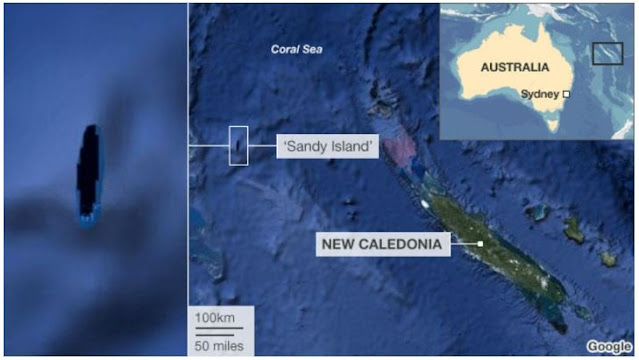
Sandy Island which has been charted since 1774 as being located near New Caledonia in the South Pacific seems to have disappeared mysteriously without a trace. Sandy Island became a subject of intrigue and in 2012, scientists headed to the area to find for themselves if there was any such island. To their surprise, they found nothing but blue waves of the sea.
According to Wikipedia, Sandy Island (sometimes labelled in French Île de Sable, and in Spanish Isla Arenosa) is a non-existent island that was charted for over a century as being located near the French territory of New Caledonia between the Chesterfield Islands and Nereus Reef in the eastern Coral Sea.
 |
| Image source: news.com.au |
On 14–15 September 1774, Captain James Cook charted a "Sandy I." snaking between 19°–20° S latitudes and 163°50'–164°15' E longitude off the tip of New Caledonia. Historically, the island was believed to be 24 kilometres long and five kilometres wide.
Sandy Island was first reported by the whaling ship Velocity in 1876 and first mentioned on a British Admiralty chart in 1908. But future expeditions failed to find the island, and it was removed from some official hydrographic charts by the 1970s.
The island gained wide media and public attention in November 2012 when scientists from the University of Sydney using the R/V Southern Surveyor (an Australian research ship) passed through the area, they found only the blue ocean of the Coral Sea. The island was quickly removed from many maps and data sets, including those of the National Geographic Society and Google Maps.
 |
| Image credit: bbc.com |
Scientists headed to the area and recorded ocean depths to be more than 4,300 feet, suggesting there was no chance of anything lurking beneath the water that would previously have been visible.
Australian newspapers have reported that the invisible island would sit within French territorial waters if it existed - but does not feature on French government maps.
Australia's Hydrographic Service, which produces the country's nautical charts, says its appearance on some scientific maps and Google Earth could just be the result of human error, repeated down the years.
The British Society of Cartographer’s president Danny Dorling told the Guardian that it is still possible the island does exist nearby - and that someone may have found an island but ‘put it in the wrong location’.
The errant island stuck on some maps and then possibly crept into digital databases like the widely used World Vector Shoreline Database, which was developed by the U.S. military.
But what did the crew of the Velocity see in the first place that led to the false discovery of Sandy Island in the 19th century?
There is no official explanation as to why several sightings of Sandy Island have been seen over the years, but many experts believe that the island may have been the floating remains of a submerged volcano or coastal subaerial eruption.
References:


Please don't put your website link in Comment section. This is for discussion article related only. Thank you :)